The UCSB Shoreline Project is funded by the State Coastal Conservancy to support implementation of the University's Sea Level Rise Adaptation Strategy. It launched in the Spring of 2025 and will continue through early 2027.
Our Vision
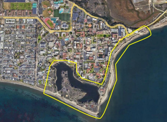
The UCSB shoreline is an exceptional resource and home to a variety of recreational beaches, as well as unique coastal and wetland habitats that remain crucial to the state's ecosystem. The first efforts to implement the UCSB Sea Level Rise Adaptation Strategy (SLRAS) are through the Shoreline Adaptation Project, focusing on the Campus Lagoon area and the Lagoon Road corridor. The primary goal of the Project is to facilitate future shoreline adaptation to protect university functions, infrastructure, beaches, coastal access, habitats, and cultural resources, and allow natural shoreline erosion and processes to continue without seawalls or other hard shoreline protection interventions. The objective is to anticipate potential sea level rise impacts on the residential, built, and natural systems of the campus, while addressing the statewide requirements of the California Coastal Act, like protecting public shoreline access and sensitive coastal habitats.
The Shoreline Adaptation Project sets forth a phased, managed approach to coastal change that promotes:
- Resilience through ecological restoration and sustainable design;
- Integration of science, policy, and community engagement; and
- Protection of the natural and social benefits that define UCSB's coastal identity.
Current Areas of Focus
The Campus Lagoon Shoreline (Area 3) and the Lagoon Road Corridor (Area 4) are highly sensitive zones where biological, cultural, and community values, resources, and infrastructure intersect. Planning in these areas calls for a system of managed coastal adaptation, including the protection of campus facilities and infrastructure, public shoreline access, habitat preservation, and cultural resource protection.
Planning in these areas focuses on:
- Maintaining coastal processes while minimizing the risks of cliff erosion, flooding and extreme storms and wave
- Conservation of sensitive habitats and cultural resources
- Ensuring maximum public access to and along the shoreline
- Balancing coastal resource protection with infrastructure and campus facilities resilience
- Robust community engagement, including to address social equity
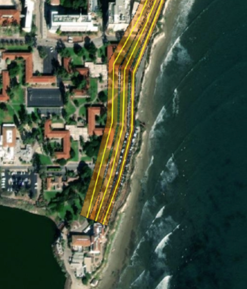
Projected Cliff Edge with 0.5, 1.0 and 2.0 meters of sea level rise.
Areas 3 and 4 along the UCSB campus coastline are calling for immediate attention and action; even so, numerous longer-term adaptation strategies must also be considered. The SLR Adaptation strategy incorporates an “adaptation pathway” approach that leverages monitoring of environmental and social change to anticipate future adaptation actions. The goal is to prepare UCSB to adequately respond to sea level rise and refrain from reactive, maladaptive actions.
Recent Reports
The Shoreline Adaptation Project is in the midst of creating a more detailed strategy for how to adapt to UCSB's eroding bluffs and berms. The on-campus team and consultant group are investigating coastal processes on campus and identifying coastal resources and campus facilities that are vulnerable to sea-level rise. The work to date has been published in the following reports:
- Campus Lagoon Studies Technical Memorandum presents the hydrology and lagoon modeling results for Campus Lagoon, including its watershed inflows, managed water levels, water and sediment quality, existing outfall infrastructure, and potential future changes in lagoon behavior under the “No Action” scenario.
- Lagoon Road Studies Technical Memorandum addresses the UCSB coastal corridor along Lagoon Road between the eastern campus roundabout and Campus Lagoon, including the eroding East Bluffs. This memo assesses adaptation considerations for infrastructure, traffic and pedestrian circulation, and beach and bluff erosion.
Appendices to this memo include:
- Appendix A – Shoreline Evolution Model Technical Memorandum. This report presents the results of the historical rates analysis and shoreline evolution model of bluff and beach dynamics at Lagoon Road. Current site conditions, the underlying geological and erosional processes, and coastal dynamics are analyzed to provide a foundation for developing and evaluating conceptual alternatives to increase UCSB’s coastal resilience.
- Appendix B – Bluff Erosion Projection and Lagoon Road Corridor Setback. This report presents results from the bluff-edge projection analysis along Lagoon Road, which focuses on identifying built assets requiring the most immediate attention.
- Appendix C – Utility Corridor.
- Appendix D – Roadway Corridor
Please contact the Campus Planning and Design Office at planning@bap.ucsb.edu to request access to Appendix C and D.
Thank You to Our Partners and Supporters
The Shoreline Adaptation Project is a partnership between the Ocean & Coastal Policy Center (OCPC) at UCSB, situated within the Marine Science Institute (MSI), and the California Coastal Conservancy. Additional funding provided by the UCSB Associated Students Coastal Fund. Through continued monitoring, analysis, and collaboration, we seek to maintain a resilient and sustainable shoreline that supports the University's mission and the broader coastal ecosystem.
Contact Us
Questions can be directed to Dr. Charles Lester (charleslester@ucsb.edu), Ocean & Coastal Policy Center, Marine Science Institute, UCSB.