Overview
In October 2020, Chancellor Henry Yang formed a Coastal Planning Science Advisory Board composed of Statewide and University scientists, researchers, and policy makers who collectively informed the science behind the University’s Sea Level Rise Adaptation Strategy (SLRAS), and collaborated on policies within the SLRAS. The SLRAS received extensive public and agency review, including collaboration with the local Chumash to ensure cultural resources are protected over time. Implementation of the SLRAS will address potential sea level rise impacts to campus buildings, infrastructure, and coastal resources, including campus beaches, public access trails, and ecological areas such as the Campus Lagoon and Coal Oil Point Reserve, through monitoring of erosion, flooding, and other shoreline changes. The SLRAS provides a framework for adaptive management studies and action in response to sea level rise over short (0-10 years), mid- (10-30 years), and long-term (30-80 years) planning horizons. The SLRAS fulfills the Long Range Development Plan (LRDP) requirement to address the impacts of rising seas on the campus. This plan assesses the vulnerability of UCSB’s natural and built environments to erosion, flooding, and other coastal hazards, anticipating up to 2 meters (6.6 feet) of sea level rise by 2100.
Why It Matters
A remarkable resource, the shoreline of UCSB is home to popular recreational beaches, wetlands, and habitats of statewide significance. Situated on an elevated marine terrace, UCSB's campus provides some natural protection from coastal hazards. Still, the campus faces lasting environmental change and risks from shoreline erosion, flooding, and rising water levels that will continue to worsen over time. Vulnerable locations stretch from the eastern shoreline near Goleta Beach, the East Bluffs along Lagoon Road near Anacapa Hall, the Marine Science Institute, and the Campus Lagoon, which faces periodic flooding. Bluff retreat in both areas poses risks for campus infrastructure, public beach and trail access, and utilities. To preserve the academic, environmental, and cultural values of the campus, UCSB is advancing proactive adaptation planning rather than relying on reactive responses to coastal change.
Adaptation Pathways
The SLRAS applies an adaptation pathway approach, which integrates:
- Ongoing environmental and social monitoring
- Vulnerability assessment and adaptive planning
- Triggers for prompt adaptation measures
The Strategy uses ongoing environmental and social monitoring to guide phased responses over time. These responses aim to avoid temporary fixes and promote long-term resilience, sustainability, and ecological restoration.

Specialized adaptation pathways of this plan are designed to minimize sea level rise damage to the University's human, built, and natural environments while meeting the requirements of the California Coastal Act. The strategy calls for an assessment of anticipated coastal hazards, regular monitoring, study of implementation options, and effective adaptation to changing shoreline conditions. The pathways additionally embody the University’s vision to foster campus resilience and protect its natural shoreline through a phased, managed adaptation plan.
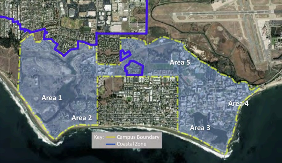
Key actions across five shoreline areas include:
- Monitoring and protecting habitats like Devereux Slough and Coal Oil Point Reserve;
- Managing bluff erosion near Lagoon Road and critical infrastructure;
- Gradually opening Campus Lagoon to tidal flow;
- Evaluating relocation of vulnerable buildings and utilities; and
- Enhancing public access while protecting sensitive ecosystems.
The SLRAS also prioritizes wetland restoration, managed retreat, and community engagement, including consultation with the Chumash community, through thoughtful and science-driven planning.